When I planned the Sydney trip, knowing I’d be based in Randwick rather than in the city, I started looking around for places to explore. University of NSW stood out on the map as being (a) very close to where I’d be staying and (b) very big. It was an obvious candidate.
On our first day, when everyone else wanted to stay back at the hotel to rest after the flight and stay out of the heat, I decided to go out and have a look around. I headed up the road towards High Street.
High Street stretches from the junction of Avoca Street and Belmore Road in Randwick to Anzac Parade in Kensington. The first third of the block, until Botany Street, is taken up by the Prince of Wales Hospital. The rest of it is UNSW territory on one side and Randwock Racecourse on the other.
The first part of that block is filled with the medical faculty buildings, after which is a large open space where the Sir John Clancy Auditorium sits. And the building that first caught my eye as I was walking past.
The Chancellery.
UNSW Chancellery
Instant love!
UNSW Chancellery
Also, very difficult to photograph.
It was the first place I came back to the next morning with my camera to try . . .
UNSW Chancellery
I couldn’t find much about the Chancellery on UNSW’s website, other than it appears to have been built over 1965-66.
They have some great images of it from Max Dupain, who was UNSW’s main photographer over the period 1959-1970, in their archive. Many of these, along with photographs by historian Isadore Brodsky, document this building’s construction.
UNSW Chancellery
I found some cool steps around the side with some unpainted concrete.
Chancellery steps
It was a great start to my exploration of the campus.
One of the references I took with me on my recent trip to Sydney was the Brutalist Sydney map. It covers a massive area of Sydney from Penrith to Pennant Hills and Circular Quay to Sutherland. This is way more ground than I was intending to cover in the week I was there, when my main plan was to explore Randwick.
At a point where many Brutalist buildings within Sydney are either being ‘disfigured’ or demolished, this map reveals an incredible and inspiring range of late modern projects that contribute to a functioning and modern-day city. Many of these buildings while being listed as significant on various heritage lists, have limited owner support due in part to a shift in socio-political thinking especially away from government led design and government owned projects. For many of these buildings, their current failing is they once symbolised government investment and a desire for civic inclusiveness. Given this current political climate and the pressure for ongoing development, the Brutalist buildings of Sydney indeed require our attention as we will never be able to match this level of craftsmanship again.
Glenn Harper, Brutalist Sydney
Not being familiar with Sydney architecture, I don’t know how many of these buildings might be in this situation. There is one that I’m very aware of, which I’ll talk about in a later post, but I’m sure there are many many others. I don’t even know if all the buildings on the map even still exist, given it was published in 2017. I’m sure many of them will have been “modernised”.
Glenn describes how, as these buildings were design and constructed, many of them through the NSW Government Architect and architects of the NSW Public Works Department, there was a need for “access to high quality concrete, artistry which combined a variety of concrete or brick textures, and appropriate engineering advice and structural detailing to convey ‘memorable form’.”
As I was sitting in my hotel room in Randwick staying out of the heat, and wondering what buildings to visit next, I noticed there were two University of NSW buildings listed that had somehow escaped my attention on my previous visits.
Decision made!
Sir John Clancy Auditorium (1971)
The first was one I must have walked past and not noticed. This is Sir John Clancy Auditorium, designed by Fowell Mansfield Jarvis and Macluran, with M S Holmood as project architect. It was built in 1971.
Its original sculptural form was “overshadowed by later developments” around it, and it was refurbished in 2019, with new canopies added, including this new, very visible glass entrance. So it looks significantly different to its original design (which you can see at the UNSW website – look for the top picture, Kensington Campus 1970s on the time line).
They also seem to have this thing at UNSW for painting concrete.
Substantial alterations plus paint equals I totally missed this on my earlier visits.
The second UNSW building to feature on the map is Goldstein Hall. It was designed by the NSW Government Architect (at the time, Dr Edward Herbert Farmer), with Peter Hall as project architect and built 1962-1964.
Goldstein Hall (1962-1964)
This building (some sources say the dining room) won the Australian Institute of Architects (NSW Chapter) Sulman Medal in 1966.
Goldstein Hall
Note the paint. I say no more.
Goldstein Hall
Goldstein Hall is a residential college and you can see some early photos of it from the 1960s here. It sounds like the building was updated in 2012-13 and the dining room has also been upgraded.
Goldstein Hall
The redesign project by TKD Architects also “saw the revitalisation of the original 1964 Bert Flugelman sculpture courtyard, a vibrant outdoor space within the expanded residential college”.
Bert Flugelman sculpture courtyard, Goldstein Hall
Completely random fun fact, Bert Flugelman also created the Spheres (aka Mall’s Balls) sculpture in Rundle Mall in Adelaide and the Cones in the Sculpture Garden at the National Gallery in Canberra. This UNSW sculpture from 1964 was one of his early pieces.
University of NSWwas officially founded in 1949, but can trace its origins back to the Sydney Mechanics Institute in 1843 and the Sydney Technical College. It was originally known as NSW University of Technology.
Its main campus is in Kensington, where it takes up the entire block between Anzac Parade and the Prince of Wales Hospital in Randwick.
UNSW archives tell me that when the university was founded, classes were still being held at the Sydney Technical College buildings in Ultimo. The administration moved to the Kensington site in 1952 and some teaching commenced there in 1953, but it continued at Ultimo until the late 1960s.
From what I’ve read, it sounds like a lot of the early buildings have now been replaced, and the campus has been expanded considerably. But there was still a lot of the mid-20th Century architecture that I’m fond of to explore.
Here’s some random buildings that caught my eye.
New College, Anzac ParadeUniversity TerracesWarrane College, Anzac ParadeMorven Brown Building (opened 1966)UNSW Global, Anzac ParadeSchool of Electrical Engineering & TelecommunicationsUNSW LibraryUNSW LibraryBrick detail near Central Lecture BlockMorven Brown Car ParkBasser Steps
The Fig Tree Theatre (below) is one of the oldest buildings on the campus. It’s located on the lower part of the campus, which was originally the Kensington Racecourse. The site housed a military camp during the Boer War and World Wars I and II and later, a migrant hostel.
The theatre was built in 1948 as a recreation hall for the migrant hostel. NIDA used it as a theatre between 1963 and 1987, and it’s now a performance space for the university and the wider community.
I recently spent a week in Randwick, NSW. I’d never been there before but discovered, thanks to Randwick City Council, that it has a lot of art deco architecture.
In the 1920s-1940s, there was a massive increase in residential building across Greater Sydney, including Randwick, to accommodate the population boom between the world wars. It figures that, as the art deco style was popular in that period, there are a lot of buildings of that style in the area.
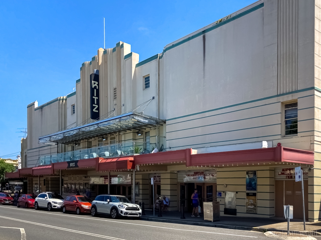
The Ritz Cinema (1937), St Pauls Street
Randwick City Council held an exhibition of photos by resident Alan Lloyd, who had documented a lot of the buildings, in 2013. This became two walking tours of Randwick and Coogee, which were so popular they developed self-guided versions for each suburb.
The Ritz (1937)
I’d found the Randwick one a few years ago but hadn’t realised there was a Coogee one as well!
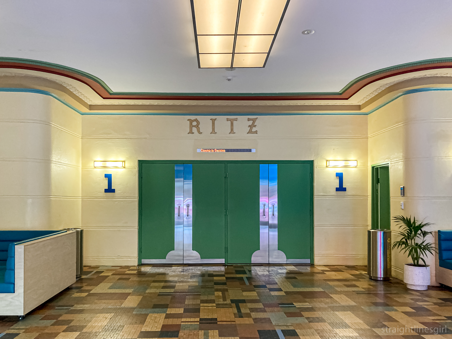
The Ritz interior
My goal for the week was to find all 20 buildings on the Randwick walk and photograph them.
It was easier said than done, mainly because, due to my early morning starts, I ended up with a lot of uneven light. And there were photos I definitely could have used a tripod for.
I also missed one because the walk brochure didn’t give the actual address of the building I was looking for and I got distracted by a more modern building . . .
Don Juan Avenue. Not what I was looking for but I like it.
It took me three days to find all the buildings, and I discovered some other cool buildings along the way. So this is going to be a series of several posts of my week in Randwick and other places around Sydney. (I also wrote a travel blog about my week in Sydney at my personal blog.)
Today’s photos are the first six buildings from the art deco walk, which starts at St Pauls Road at an area called The Spot, which is a small shopping centre with a lot of cafes and restaurants.
Salvios Shop (pre-1925), 34 St Pauls StreetThe Spot (c. 1920), 46-50 Perouse RoadThe Spot (c. 1920), 46-50 Perouse RoadThe Spot (c. 1920) 46-50 Perouse RoadGower Galtees (1940), 8-10 Coogee Bay RoadGower Galtees (1940), 8-10 Coogee Bay RoadAda Street flats